Recent View of Arctic
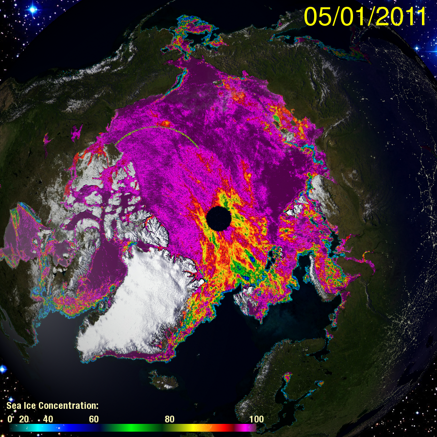
Cryosphere Today websiteThe Cryosphere Today website is very interesting, I recommend it. The above image was taken from it. What it shows is actually quite disturbing.
Every winter the Arctic sea ice extends and freezes its normal maximum area of about 14 million square kilometers (msk). That is normal for now. If you go back to 1980, the Arctic normally reached a maximum ice are over 16msk. In any case, the area that was frozen over would be completely covered with ice.
The completeness of the ice coverage can be seen by the color given to the ice by the Cryosphere Today website.

Compare the two images from February 24th 2007 and 2011. See the difference? The 2007 image is a solid purple. That means that the Ocean is completely covered with ice -- 100%. That is good. That is to be expected. After all, in 1980, the average ice thickness was 17 ft, and was primarily multi-year ice.
The 2011 image is NOT solid purple. The Arctic is NOT completely covered in ice. The ice concentration is less than 100%. The colors indicate that the concentration is 95%, 90%, and as low as 80%. Water is actually exposed to the air in those places. If you were to be walking there, you could drown.
This is extraordinary. Remember the image for 2007 shows the condition of the Arctic in the year when a summer ice minimum of 3msk was reached. That was a serious meltback that blew away previous records by one million sq. kilometers! When that happened, climatologists rushed to their models to update them. None of the climate models predicted that huge meltback.
But, even that year showed 100% ice coverage the preceeding winter. This winter is different. What does it portend?
First, I think the there should be a huge meltback this summer, easily beating the 2007 record. I would not be surprised to see a summer ice minimum of 2msk.
Secondly, I see a trend towards less and less winter ice. The loss of sea ice area until now has shown a decrease in area at the margins. Now it is losing ice throughout, and it is doing it in WINTER! If the cold Arctic air cannot freeze the ocean in the winter, then that means that Arctic Ocean is becoming to warm to freeze.
Note Hudson Bay. It did not freeze over until January, two months late. But, it did freeze over. Note that its color is a solid purple, so it ishows 100% sea ice concentration. It may be thin ice, but it covers completely. The Arctic is not doing that.
Now another thing that may be happening is wave action. The Arctic is an ocean which means waves. If the ice is not thick enough, then wave action will break it up. So we might be seeing the development of ice and water mixture, a sort of ocean slushy. This may be just as bad as having the ice melted, from an albedo effect. If you notice, broken up ice floating in water, becomes clear and takes on the color of the water. So, ice reflectivity is lost. Sunlight, when it comes in the spring, will start being absorbed before the ice gets fully melted.
As there is less summer ice, more solar energy is absorbed, warming the ocean that much faster.
Now as the ocean warms, then the winter ice concentration should be expected to decline. Now it is at 95% over much of the area. In future years, may it go down to 90%, 80%, and even lower. If this trend continues long enough, shouldn't we expect to see an ice free Arctic in the winter? It might take several hundred years to reach that condition, but unless something happens to reverse the underlying conditions causing the trend, then how can it be avoided?
Impact on Greenland
The importance of Arctic ice loss is on loss of albedo and the warming of the Arctic Ocean. The reason why that is important is that is where the climate of Greenland is determined. When ice is year around to the north of Greenland, then all the weather coming to Greenland is freezing during the entire year. The ice cap is safe.
However, when the Arctic ocean is open water, it is above freezing. Thus, all weather systems going over it to Greenland become above freezing. Greenland melts. The less ice, and the warmer the ocean, the warmer the air, and the faster Greenland melts.
The climatologists foresaw an ice free summer Arctic happening soon. Maybe as soon as 2020. However, none foresee an ice free WINTER Arctic!. This could mean that Greenland's melt season would be year around. Not just for a few months in the summer.
If that happens -- HYPER MELT time. Now we could be talking about accelerating the melting of Greenlands ice cap by orders of magnitude. To me, an increase of melting by 100 times more the current melt rate would not be surprising.
This may seem extreme, but it is just a matter of deduction. Think about it.